
Sponsored by the American Geosciences Institute, The week of October 12th week is Earth Science Week. The theme is “Mapping Our World.”
I love maps. Maps come in all shapes, sizes, and configurations. They tell us about more than the size and shape of continents, oceans, rivers, lakes, and ponds. They illustrate our travels, pinpoint natural resources and the places we live, shop, learn, and play.
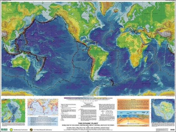
In my 30s, I returned to college where my favorite earth sciences class was geology– especially the impacts of plate tectonics. This United States Geological Survey poster hung on my wall for years. The heavy black lines extending from off Australia up and across the Pacific at Alaska and down to South America are studded with red dots. They are volcanic hotspots mapping the ridge of fire, earthquakes, sometimes tsunamis, all products of the earth’s restless undergarments.
My uncle and I spent years plying the waters of our family’s history. When my first ancestors ventured from Europe to America in 1633, the world map looked like this. Check out the size of Antarctica! Brrrr!

World Map 1633
Maps had improved significantly by the time my 4th great grandfather and his son sailed the world’s oceans as master mariners the early1800s to the Civil War.

World map, 1863, showing routes of steam navigation companies, lines of steam packet communications, telegraph lines, tracks of sailing vessels, ocean depths and currents.
You can’t get from here to there or run a war without maps or mapmakers.

Civil War-Cartographic engineers Camp Winfield Scott
One of the most unusual maps is Buckminster (Bucky) Fuller’s, Fuller Projection or Dymaxian Map. He wanted to show the planet as one, connected “island,” moving away from the perception we’re separated by a belief the planet has to operate on its “you or me.” Bucky preferred, rightly so, to use AND as the separator. See how a few cartographers have re-imagined his map for the 21st century.
My most recent mapping interest involved sea turtles and research for Elizabeth’s Landing. Elizabeth learns how small transmitters, glued to turtles’ backs, beam signals to satellites, which beam the coordinates back to scientists. Scientists use information on where sea turtles feed and breed in conservation efforts all over the world’s oceans. As Elizabeth says, “…a turtle talking to outer space. How cool is that?”
Olive ridley sea turtle movements off Bangladesh. Tracked via satellite transmitter. By Marinelife Alliance and seaturtle.org
Update 10-8-14: Story maps are a writer’s tool for designing and revising plot, character behavior, or scenes that move the story forward. When I get stuck on any of these, I stop and work out what’s happening to my character and why, graphically, with my character or plot situation in the center and all the things that are happening radiating out from there. Gettiing all this out of my head into a visual clears my thinking like a warm summer breeze clears haze over the hills. Here’s a simple Plot Map that’s great for kids, or anyone interested in desiging or analyzing a story

thanks to Schoolbox and Angela E. Hunt
What would you like to map this week? The floor plan of your house, your block or neighborhood? All the plants in your garden where pollinators like bees, butterflies, and hummingbirds hang out? Choose a spot, then map out and plant a new garden for them.

Butterfly garden plan-About.com Gardening
How about how your family got from where it started to where you are now? A family vacation in 2D? Show where you went (or dream of going) and photos of what you saw–mountains, rivers, forests, city buildings, a baseball stadium? Use flat maps, research Internet maps and photo sites. Just like books, a map can take you anywhere.
Visit AGI for more map project ideas (or teacher lesson plans using maps).
What part have maps played in your life? Love them, confused every time you look at one? Share your thoughts in the Comments section and links to your projects.
****

Katy, I loved this piece! Hmm..Shall I make a map or take a nap? (See you in Nov.)
Hey, desert gal, good to hear from you. Glad you liked the post. Imagine how many people used maps, even one in a trail boss’s head, to find and settle your beloved Nevada.
You remind me that I forgot to include Story Maps. I used a variety to help me plan out, write, guide, and revise the plot, characters, and scenes in Elizabeth’s Landing. I’ve added a fun plot map, especially for kids, to the post above.
See you in November! I know you won’t need a map to find your way.
My son’s fascinated by maps. I think a lot of their appeal has to do with the sense of possibilities they offer, the gift of an intriguing space in which Things Could Happen. Any map is a potential treasure map.
Hi Nick,
I love your view of maps as gifts of possibilities and promise. Thank you so much for that. Right now, I’m traveling and relying on maps to discover places I’ve never been. So your comment really strikes home.
How exciting your son loves maps, too. I imagine that enthusiasm will serve him well throughout his life.
I have formed a new appreciation for maps in the writing process. All of our stories take place SOMEWHERE, and studying a map of that place (or creating a map if the place you’re writing about hasn’t been charted!) can bring revelation. Did you know, dear Katy, that the intersection we know as Brown’s Corner in Woodland is listed that way on the AAA map? Or that there’s a waterway known as the South Fork Ditch running thru a portion of town? These facts will not likely make it into the essay I’m trying to write, but learning about the world thru maps is wonderful! Great post!! xoxox
Oh, home girl…passed by Brown’s Corner not long ago. How it’s changed since the days of our youth. Gas station, to bar, to rockin’ & rollin’ on the weekends. Reuse/recycle. I have a 1960+/- photo of the family car and boat out front, probably after gassing up for the boat’s maiden voyage on Lake Berryessa. Literature was involved — the boat named Mehitabel after an alley cat in Don Marquis’ book Archie and Mehitabel, Kept Dad company during WWII.
I remember being intrigued by the tiny Huey ditch that runs (or used to) behind Wal’s place. When I ran the Resource Conservation District, one of our projects was mapping a watershed, including one of the major sloughs running through it.
Then, there is the most complex mapping project–the trails of the human heart.